Ocean/sea seems like small words but is the most significant and prominent component of our Blue Planet. They play a vital role in modulating climatic processes, regulating Earth’s energy balance, and supporting the basic needs of humanity. So, preserving it should be our topmost priority. But to achieve it, we must first detect the issues from the micro to macro level.
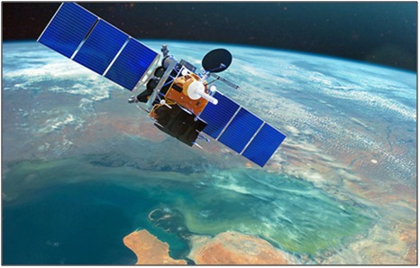
Do you know Satellites can see the ocean from space? – Not only can they see, but observe the ocean too.
Satellites with their application of remote sensing from orbits, satellites can provide us a lot more information that would be possible to get from the ocean surface. Researchers from organizations like National Oceanic and Atmospheric Administration (NOAA) used satellite data to close ocean research.
Let’s talk about ways in which satellites could tell us about the ocean/sea.
SST is the measurement of energy due to the motion of water molecules in the sea/ocean. It is one of the vital components of the climate system. It exerts a significant influence on the exchanges of energy, momentum, and gases between the ocean and the atmosphere.
Satellites can measure SST from 10 µm below the surface (infrared bands) to 1 mm depth (microwave bands) using radiometers. The spatial images of SST show the pattern of water circulation like locations of coastal upwelling, ocean fronts, eddies, and exchanges between the coastal shelf and open ocean.
Ocean emits radiations in either infrared or microwave wavelengths. The amplitude of these wavelengths varies with temperature for different regions. The satellite measures these variation bands from space with the help of sensing instruments and generates data, and that helps scientists to measure SST.
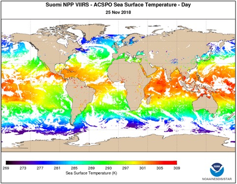
The most common sensor used for measuring SST is the Visible Infrared Imaging Radiometer Suite (VIRS) by NOAA and NASA Suomi NPP satellite. VIIRS captures new data every day, allowing the team to piece together a series of maps showing SST variation with time for different locations across the globe.
NASA’s Terra and Aqua satellites use instruments like Moderate Resolution Imaging Spectroradiometer (MODIS), which can gather more SST data in 3 months than all other combined measurements taken before the advent of satellites.
Sea surface color is the water hue due to the presence of tiny plants containing the pigmented chlorophyll within phytoplankton and other oceanic particles like sediments. This phytoplankton consists of different chlorophyll concentrations, which in turn affects the changing color of the water to green hues from the deep blue of its pure state.
Satellites sensing provides information on chlorophyll and other oceanic particle concentrations. The color observed by satellite sensors (MODIS/VIIRS) is the radiance emanating from the ocean due to scattering by phytoplankton, sediments, and DOM (Dissolved organic material).
The data of sea surface color reveals the variability in the distribution and concentration of phytoplankton and the extent of primary productivity, which permits a quantum leap in understanding oceanic processes from regional to global scales. This data helps researchers determine the impact of floods along the coast, detect river plumes, and locate harmful algae blooms that can kill marine species.
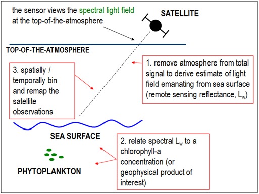
How can satellites get the data to determine ocean color? – Here Lw is the water-leaving radiance.
Rising sea level is one of the clearest signs of increasing global warming. There are two reasons due to which we experience a rise in sea level, and both depend on heat:
Unfortunately, we can’t put a ruler to measure the rise in the sea level. But what is the solution?
NASA comes up with an idea with its JASON-3 satellite, which carries a radar altimeter. This instrument uses radio waves instead of a ruler to measure distances.
The satellite bounces radio waves off the ocean surface and then times how long these signals take to return. These radar measurements can be combined precisely with known spacecraft orbit to provide global basis measurement of sea level with unprecedented accuracy.
This turned out to be the best way to calculate the rising sea level.
Satellite oceanography is the best technique that can measure the minute variations like coral reefs in the sea to map the topography of the sea bed. Ocean surface has broad bumps (swells) and dips due to gravity that mimics the ocean floor’s topography. An underwater volcano or tide can too attract water which can cause a slight bump.
It would be gradual to see the bump from the ship, so researchers use satellite altimeters as they can accurately gauge distance down to the ocean surface and detect and measure the variations. These altimeters use micro and radio waves to time the interval between transmitting a short pulse and receiving a reflection back from the surface.
Sea/ocean plays a major role in regulating the planet’s weather and climate. To determine whether data is the most well-known application of satellite technology,
Weather satellites use radiometers (not cameras) that can scan the Earth to form images. These instruments have an antenna, a scanning mechanism, and a detector that can detect either visible, infrared, or microwave radiation for monitoring weather systems.
The data provided by these instruments are in the form of electrical voltages, which are digitized and then transmitted to ground stations. Then, this data is released to the weather forecasting center, and they made them available to the audience as images.
As weather changes immediately, do you guys know the time from satellite measurement to image availability is less than a minute?
The weather satellite system is composed of two types of satellites:
Oceans and seas are both important components of our planet. But nowadays they are getting polluting and to stop that we need trackers.
Satellites can be used to track pollutants, sediments, and one of the major rising issues of microplastics in the sea/ocean. These tiny particles can cause a major threat to the marine ecosystem, industries, and communities.
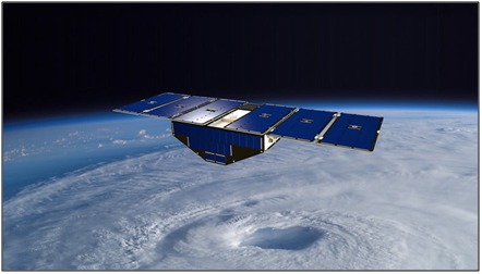
Satellites generally use the Cyclone Global Navigation Satellite System (CYGNSS), which was launched on 15th December 2016 and was responsible for collecting the first space-based measurements of surface wind speeds in the inner core of tropical cyclones.
This system is made up of a constellation of eight microsatellites. The observatories provide nearly gap-free earth coverage using an orbital inclination of approximately 35 degrees from the equator. This inclination allows the CYGNSS system to measure ocean surface wind fields with unprecedented temporal resolution and spatial coverage under all conditions.
This data allows the team to detect the roughness of the ocean surface as the area of the roughness of water explains the accumulation of plastic material. By this method, the detection of harmful materials on a global scale can be done, which in turn serves the purpose of preventing ocean pollution.
Just remember !!
If few drops can make an ocean and the same number of drops can destroy it. So, we must preserve every single drop, and detection of our precious ocean from space can make this job a lot easier.
Suggested Reading: Low Cost Small Satellite to explore our Solar System
Author
A Historic Moment for India in Space India has marked a monumental return to human…
How Microgravity Is Unlocking the Next Frontier in Health, Medicine, and Beyond Introduction Space-based biotechnology…
In a move that has sent shockwaves through the space industry, NASA has decided to…
The Indian Space Research Organisation (ISRO) took a historic step today, February 27, 2024, by…
Get ready to witness India’s third lunar expedition with Chandrayaan - 3 aiming to touch…
Image made through Photoshop by Palak Part 1: Overview If you consider yourself a part…
View Comments